|
|||||||
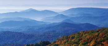
Estimating Impacts of Population Growth on Ecosystem Services for the Community of Albemarle County and Charlottesville, VAExecutive SummaryThis study is one of the main components of the Optimal Sustainable Population Size (OSPS) Project, begun in 2007 by the non-profit organization Advocates for a Sustainable Albemarle Population (ASAP). The aim of the OSPS Project is to initiate research that can help estimate the biological carrying capacity and the socio-economic optimal size of this community, which has a current population of about 135,000. This study quantifies ecosystem services for Albemarle County and Charlottesville, VA, and investigates the impacts of potential population growth on these services.
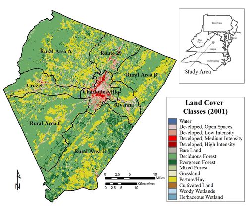
This figure shows land cover and land use patterns for the city of Charlottesville and Albemarle County. The majority of the study area is forest or farmland, but degradation of ecosystem services are already apparent with just 10% of the study area developed. The wide range of resources and processes supplied by natural ecosystems include benefits of immense value to human populations, from erosion and flood control to crop pollination. Population growth and the resulting land use changes pose threats to ecosystem services. This research used American Forests’ CITYgreen software, data sets that include the National Land Cover Data set, U.S. Census population data, and GIS data sets from Albemarle County and the City of Charlottesville to quantify a selection of ecosystem services, including water-related services (i.e. stormwater retention, water pollution removal) and air-related services (i.e. carbon sequestration and storage, air pollution removal). For most of the ecosystem services analyzed, two population levels are observed where degradation accelerates. At a 50% increase in population (pop.186,429) services within the developing sub-study areas (i.e. Charlottesville, Crozet, and the Route 29 corridor) begin to decline markedly. Up to a 125% population increase (pop. 279,642), degradation of ecosystem services is contained within the developing sub-study areas; as population exceeds this threshold degradation becomes widespread, impacting all of the rural areas. It is important to emphasize that ecosystem degradation occurs unevenly across the study area. While ecosystem services at the level of the entire study area appear to be sustainable up to a 125% population increase due to the continued functioning of the rural areas, this masks the degradation that is occurring in the developing areas. The results of this first OSPS Project study clearly indicate that if growth continues, planners will have to balance the needs of the human population with local ecosystem health. We note that while careful development can continue in the short term, it clearly cannot be sustained forever without sacrificing important ecosystem services. There are two main lessons that can be garnered from this research. First, one of the key findings of this study is the importance of a development strategy that encourages growth and efficient use of land in the developing areas while preserving the rural areas. This kind of strategy has the best chance of offsetting the impacts of future population growth in the short term. A strong urban forestry program is also important for this approach so that residents in the more densely developed areas can benefit from the ecosystem services provided by trees. Second, even with these land use strategies in place, unabated population growth and the accompanying land development will negatively alter ecosystem services across the entire study area, suggesting that the identification and maintenance of an optimal population size should be a goal for local decision makers. Download the full report (PDF)Funding SourcesThe Optimum Sustainable Population Size (OSPS) Project, of which this report is one component, was started in 2007 by the non-profit organization Advocates for a Sustainable Albemarle Population (ASAP), and is funded by contributions from the County of Albemarle, the City of Charlottesville, The Colcom Foundation, and donations from ASAP members and friends. AcknowledgementsThe authors wish to thank Jack Marshall and Tom Olivier for their guidance and comments; Everette "Buck" Kline of the Virginia Department of Forestry (VDOF) for commenting on earlier versions of this report, and in providing guidance in the identification of ecosystem services during the early stages of this research; Francesca Toscani for her editorial assistance; and Dr. George Pomeroy for his support through the Center for Land Use. |
|||||||
|
|||||||